
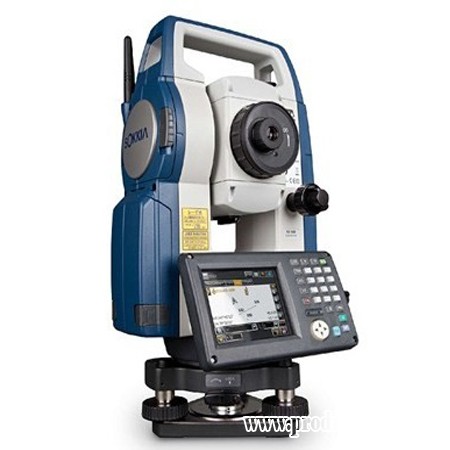
• Range of 1,640' in reflectorless mode
• Bluetooth capabilities
• Red laser pointer
• 3-second accuracy
• TSshield system
Features for the Sokkia FX 103 3 Second Total Station
• Range of 1,640' in reflectorless mode
• Range of 16,400' using prisms
• Laser plummet
• IP-65 rating
• Color LCD display
• Keypad
• USB and serial port
• Runs up to 20 hours on rechargeable battery
• MAGNET Field software
• 500 MB memory
Specifications for the Sokkia FX 103 3 Second Total Station
|
General
|
|
| Weight | 12.6 lbs (5.7 kg) |
| Dimensions | 7.5 in x 7.5 in x 13.7 in (19.1 cm x 19 cm x 34.8 cm) |
| Warranty | 2-year |
| Protection Class | IP65 (dust proof and water jets resistant) |
| Internal Memory | 500 MB |
| Software | MAGNET Field |
| Guide Light | Green and red LED; Operating time: 1.3 to 150 m (4.3 to 490 ft) |
|
Angle Measurement
|
|
| Minimum Reading | 0.5-second/1-second |
| Accuracy | 3-second |
|
Distance Measurement
|
|
| Unit of Measure (distance display) | m/ft |
| EDM Accuracy (Precision) | ±(2mm + 2ppm x D) for prism; ±(3mm + 2ppm x D) for no prism |
| Minimum Reading | 500 m (1,640 ft) |
|
Tilt Sensor/Compensator
|
|
| Range | ± 6 |
| Type | Liquid |
| Method | Electronic Automatic |
|
Battery/Power
|
|
| Power Source | Rechargeable Li-ion battery |
| Battery Life | 20 hours |
| Battery Life Alert | yes |
|
Optical Plummet
|
|
| Magnification | 3x |
|
Level
|
|
| Circular Bubble Vial | 10 minutes per division/(2 mm) |
|
Telescope
|
|
| Length of Tube | 6.7 in (17.1 cm) |
| Image | Erect |
| Diameter of Objective Lens (Aperture) | 1.9 in (48mm) EDM |
| Magnification | 30x |
| Field of View | 1 degree 30 arcmin |
| Resolving Power | 2.5 arcsec |
| Minimum Focus Distance | 1.3 m (4.3 ft) |
| Reticle Illumination | 5 brightness levels |
| Reflectorless | yes |
|
Display and Keypad
|
|
| Type | Semi-transmissive TFT QVGA color LCD |
| Sides | Dual |
| Keys | Alphanumeric |
| Touchscreen | yes |
| Backlight | yes |
|
Temperature
|
|
| Operating | -4Fº~122ºF (-20ºC~50ºC) |
|
Applications
|
|
| Surveying and Construction | yes |
| Mapping and GIS (geographic information systems) | yes |
| Utilities | yes |
| Environment Studies | yes |
| Geomarking | yes |
| Archaeology | yes |
| Accident Reconstruction | yes |
|
Measurement Range (under fair weather conditions)
|
|
| Single Prism | 5,000m (16,400 ft) |
| Triple Prism | 6,000m (19,680 ft) |
| No Prism | 500 m (1,640 ft) |
| Mini Prism | 500 m (1,640 ft) |
| Reflector Sheet | 500 m (1,640 ft) |
|
Functions
|
|
| Coordinate Measurement Point | yes |
| Angle and Distance Stake Out | yes |
| Stake Out Line | yes |
| Offsets | yes |
| Missing Line | yes |
| Remote Elevation | yes |
| Resection | yes |
| Area Calculation | yes |
|
Measurement Time
|
|
| Fine | 0.9-second |
| Rapid | 0.7-second |
| Tracking | 0.3-second |
|
Laser Plummet
|
|
| Accuracy | ±1.0 mm/1.3 m |
| Class | 2 |
| Wavelength | 635 nm |
|
Interface
|
|
| Bluetooth | Class 1 |
| USB | Type A and mini B |
| Pin Port | RS-232C |
| Operating System | Windows CE 6.0 |


 GARANSI RESMI")
