

• 2.6" sunlight-readable color screen
• Built-in worldwide basemap with shaded relief
• High sensitivity quad helix GPS antenna for unparalleled reception
• 1.7 GB of internal memory
• Supports BirdsEye satellite imagery, Garmin Custom Maps and photo navigation
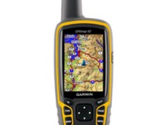
GPSMAP 62 features a 2.6" sunlight-readable 65K color screen that supports BirdsEye Satellite imagery (subscription required) and Custom Maps. Rugged and waterproof, GPSMAP 62 features a quad helix antenna for unparalleled reception and sleek new design.
GPSMAP 62 comes with built-in worldwide basemap with shaded relief, so you can navigate anywhere with ease. With photo navigation, you can download geotagged pictures from the Internet and navigate to them.
Specifications for the GPSMap 62:
|
Physical & Performance |
|
|
Physical dimensions |
2.4" x 6.3" x 1.4" (6.1 x 16.0 x 3.6 cm) |
|
Display size, WxH |
1.43" x 2.15" (3.6 x 5.5 cm); 2.6" diag (6.6 cm) |
|
Display resolution, WxH |
160 x 240 pixels |
|
Display type |
transflective, 65-K color TFT |
|
Weight |
7.9 oz (223 g) with batteries |
|
Battery |
2 AA batteries (not included); NiMH or Lithium recommended |
|
Battery life |
20 hours |
|
Water rating |
IPX7 |
|
High-sensitivity receiver |
✓ |
|
Interface |
USB and NMEA 0183 compatible |
|
Maps & Memory |
|
|
Basemap |
✓ |
|
Ability to add maps |
✓ |
|
Built-in memory |
1.7 GB |
|
Custom POIs (ability to add additional points of interest) |
✓ |
|
Waypoints/favorites/locations |
2000 |
|
Routes |
200 |
|
Track log |
10,000 points, 200 saved tracks |
|
Outdoor Features |
|
|
Automatic routing (turn by turn routing on roads) |
Yes (with optional mapping for detailed roads) |
|
Geocaching-friendly |
Yes (Paperless) |
|
Custom maps compatible |
✓ |
|
Hunt/fish calendar |
✓ |
|
Sun and moon information |
✓ |
|
Tide tables |
Yes (with optional Bluechart) |
|
Area calculation |
✓ |
|
Picture viewer |
✓ |
|
Garmin Connect® |
|
|
Garmin Connect™ compatible (online community where you analyze, categorize and share data) |
✓ |
Package includes:
• GPSMAP 62• Carabiner clip
• USB cable
• Quick start manual