

For boaters and watersports enthusiasts who want to run with the best, the rugged GPSMAP 78s features a 3-axis compass, barometric altimeter, crisp color mapping, high-sensitivity receiver, new molded rubber side grips, plus a microSD™ card slot for loading additional maps. And it floats!
GPSMAP 78s comes with built-in worldwide basemap, so you can navigate anywhere with ease. And, like the rest of the 78-series, 78s is IPX7 waterproof and even floats in water.
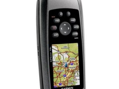
Specifications for the GPSMap 78S:
|
Physical & Performance |
|
|
Physical dimensions |
2.6" x 6.0" x 1.2" (6.6 x 15.2 x 3.0 cm) |
|
Display size, WxH |
1.43" x 2.15" (3.6 x 5.5 cm); 2.6" diag (6.6 cm) |
|
Display resolution, WxH |
160 x 240 pixels |
|
Display type |
transflective, 65-K color TFT |
|
Weight |
7.7 oz (218.3 g) with batteries |
|
Battery |
2 AA batteries (not included); NiMH or Lithium recommended |
|
Battery life |
20 hours |
|
Water rating |
IPX7 |
|
High-sensitivity receiver |
✓ |
|
Interface |
high-speed USB and NMEA 0183 compatible |
|
Barometric altimeter |
✓ |
|
Electronic compass |
Yes (tilt-compensated 3-axis) |
|
Unit-to-unit transfer (shares data wirelessly with similar units) |
✓ |
|
Floats |
✓ |
|
Maps & Memory |
|
|
Basemap |
✓ |
|
Ability to add maps |
✓ |
|
Built-in memory |
1.7 GB |
|
Accepts data cards |
microSD™ card (not included) |
|
Custom POIs (ability to add additional points of interest) |
✓ |
|
Waypoints/favorites/locations |
2000 |
|
Routes |
200 |
|
Track log |
10,000 points, 200 saved tracks |
|
Outdoor Features |
|
|
Automatic routing (turn by turn routing on roads) |
Yes (with optional mapping for detailed roads) |
|
Geocaching-friendly |
Yes (Paperless) |
|
Custom maps compatible |
✓ |
|
Hunt/fish calendar |
✓ |
|
Sun and moon information |
✓ |
|
Tide tables |
✓ |
|
Area calculation |
✓ |
|
Picture viewer |
✓ |
|
Garmin Connect® |
|
|
Garmin Connect™ compatible (online community where you analyze, categorize and share data) |
✓ |
Package includes:
• GPSMAP 78S
• Wrist strap
• USB cable
• Quick start manual