

• Real-time H-Star technology for decimeter to subfoot accuracy in the field
• High resolution VGA display for crisp and clear map viewing
• Bluetooth and wireless LAN connectivity options
• 1 GB onboard storage plus SD slot for removable storage cards
• Windows Mobile version 6 operating system
• Rugged handheld with all-day battery
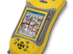
Trimble Geo XH 2008 Series
Geo Explorer Geographic Information Data Collector Trimble GeoXHHandheld 2008 Series
For high-accuracy GIS data collection and asset relocation, the Trimble® GeoXH™ handheld is the ultimate integrated solution. Engineered with H-Star™ technology, the GeoXH handheld delivers decimeter (10 cm / 4 inch) to subfoot (<30 cm) accuracy when you need it, making it the ideal device for electric and gas utilities, water and wastewater services, land reform projects, and other applications where on-the-spot positioning is crucial. The unique GeoExplorer® 2008 series combines a Trimble GPS receiver with a rugged handheld computer, built for all-day use and packed with connectivity options. Technology this clever has never been more convenient.
Specifications Trimble Geo XH 2008 Series:
| Physical |
|
| Size |
21.5 cm × 9.9 cm × 7.7 cm (8.5 in × 3.9 in × 3.0 in) |
| Weight |
0.81 kg (1.79 lbs) with battery |
| Processor |
128 MB RAM and 1 GB internal Flash storage |
| Battery |
Internal 7500 mAh lithium-ion 27.8 Watt-hours,rechargeable in unit |
| Power usage |
|
| Low (no GPS or backlight) |
1 .8 Watts |
| Normal (with GPS and backlight) |
3 .2 Watts |
| High (with GPS, backlight, Bluetooth, and wireless LAN) |
4 .3 Watts |
| Environmental |
|
| Operating temperature |
–20 ºC to +60 ºC (–4 ºF to 140 ºF) |
| Storage temperature |
–30 ºC to +70 ºC (–22 ºF to 158 ºF) |
| Casing |
Dust-proof and resistantto heavy wind-driven rain perIP 65 standard Slip-resistant grip, shock and vibration resistant |
| Drop |
0.9 m (3 ft) MIL-STD-810F, Method 516.5, Procedure IV |
| Input/Output |
|
| Expansion |
SD card slot(SD or SDHC storage cards) |
| Display |
8.9 cm (3.5 in) VGA (480 x 640 pixel) TFT, 16 bit(65,536) colors LED backlight |
| Interface |
Touch screen, 10 hardware control keys, powerstatus LED Audio system events, warnings, and notifications Soft Input Panel (SIP) virtual keyboard and handwriting recognition software |
| Audio |
Microphone and speaker, record and playback utilities |
| I/O |
USB 1 .1 client via support module Serial via optional 9-pin RS-232 power/serial clip adaptor |
| Radios |
Bluetooth 1 .2, Wireless LAN 802 .11b/g |
| GPS |
|
| Channels |
26 (12 L1 code and carrier, 12 L2 carrier, 2 SBAS) |
| Integrated real-time |
SBAS1 (dual-channel tracking) |
| Update rate |
1 Hz |
| Time to first fix |
30 seconds (typical) |
| Protocols |
|
| Data output |
TSIP, NMEA-0183 v3.0 (GGA, VTG, GLL, GSA, ZDA, GSV, RMC) |
| Real-time corrections |
RTCM 2 .x, RTCM 3 .0, CMR, CMR+ |
| Accuracy (HRMS) after differential correction |
|
| Real-time positioning |
|
| H-Star with internal antenna (within a VRS network, or <80km) |
Subfoot (<30 cm) |
| H-Star with optional Tornado antenna Short baseline (within a VRS network, or <30 km) |
10 cm |
| Long baseline (30–80 km) |
Subfoot (<30 cm) |
| Code corrections (SBAS1 or external correction source) |
Submeter |
| Postprocessed positioning |
|
| H-Star horizontal accuracy |
10 cm + 1 ppm |
| Carrier postprocessed accuracy with 45 minutes tracking satellites |
1 cm + 2 ppm |
| Code postprocessed |
50 cm |